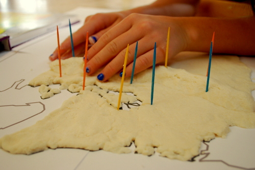
I really think they could have come up with a better word. The word “relief” is already taken. But anyway, we decided to make a relief map for Washington State History class. We can look at maps, all kinds of maps, till pigs fly, and it’s just not going to be understandable the way a 3D map will. So after defining all sorts of land and water forms and finding them in Washington State, we decided to tackle it.
I found an online site that has maps you can make different sizes, and print them at home. I chose to make Washignton State 2×2 pieces of paper, which turned out to be perfect.
Then we mixed up a bunch of dough and started plopping it on, smoothing it out on the eastern side of the state, and making mountains for the western side.
And you’ve got to remember to poke toothpicks in where you are going to want little flags. Once the dough dries, you’re outta luck.
Then we let it dry, not for the 2 days the site said, but for a week. Then she painted it.
I made the flags with tape and toothpicks. It’s Scotch brand tape I bought at Michael’s and fine tipped Sharpies we already had. Worked like a charm.
(As for the photo above, I apologize for those who live “east of the mountains” as we say, it’s not that there aren’t cool land and water forms where you are, you just aren’t as pertinent to us as where we live.)
Today we’re discussing our volcanoes. By way of volcano introduction, mostly Bill Nye The Science Guy is doing the teaching part. My part is teacher’s aide-I picked up the video from the library.
Most everyone knows Mt. St. Helens erupted in 1980. But not many people know that Mt. Rainier “officially” erupted in 1894. According to Wikipedia, it is considered one of the most dangerous volcanoes in the world. Eyewitnesses also reported eruptive activity in 1858, 1870, 1879, 1882 and 1894. Also, Mount Rainier is the highest mountain in Washington and the Cascade Range. On days of exceptional clarity, it can be seen from as far away as Portland, Oregon and Victoria, British Columbia.
Western Washington
Olympic Peninsula
School project conquered. Now I’ve got to youtube how to make a homemade volcano….


I love it!!! What a fantastic and fun project. You guys did an amazing job. 🙂